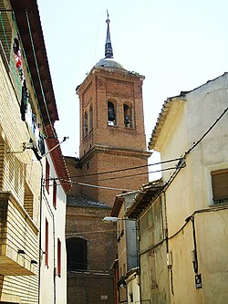
Sariñena
Appearance
Sariñena | |
|---|---|
 Bell tower of the church of San Salvador. | |
| Coordinates: 41°47′N 0°10′W / 41.783°N 0.167°W | |
| Country | |
| Autonomous community | |
| Province | Huesca |
| Comarca | Monegros |
| Government | |
| • Mayor (2019— ) | Juan Escalzo Millera (PSOE-Aragon) |
| Area | |
• Total | 275 km2 (106 sq mi) |
| Elevation | 281 m (922 ft) |
| Population (2018)[1] | |
• Total | 4,168 |
| • Density | 15/km2 (39/sq mi) |
| Time zone | UTC+1 (CET) |
| • Summer (DST) | UTC+2 (CEST) |
Sariñena is a municipality in the province of Huesca, Aragon, Spain. It is located in the Monegros comarca, near the Sierra de Alcubierre range.
The Baroque monastery of Nuestra Señora de las Fuentes is located in the municipal term.
Villages
- Sariñena town
- La Cartuja de Monegros
- Lastanosa
- La Masadera
- Pallaruelo de Monegros
- San Juan del Flumen
Twin towns
 Mézin, France
References
- ^ Municipal Register of Spain 2018. National Statistics Institute.
External links
Wikimedia Commons has media related to Sariñena.


