Hârlău
Appearance
Hârlău | |
|---|---|
 St. George Church (1492) | |
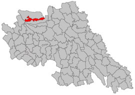
 Location in Iași County | |
| Coordinates: 47°25′40″N 26°54′41″E / 47.42778°N 26.91139°E | |
| Country | Romania |
| County | Iași |
| Government | |
| • Mayor | Gheorghiță Curcă[1] (PSD) |
Area | 40.36 km2 (15.58 sq mi) |
| Population (2021-12-01)[2] | 10,349 |
| • Density | 260/km2 (660/sq mi) |
| Time zone | EET/EEST (UTC+2/+3) |
| Vehicle reg. | IS |
Hârlău (also spelled Hîrlău, Romanian pronunciation: [hɨrˈləw]; Template:Lang-he, Template:Lang-de, Template:Lang-hu) is a town in Iași County, Western Moldavia, Romania. It was one of the princiary court cities of Moldavia, in the 15th century. One village, Pârcovaci, is administered by the town.
Population
The 2011 census counted 10,905 inhabitants, 93.85% Romanians, and 6.06% Roma. A large Jewish community used to live in Hârlău.
| Year | Number | % of Jews in the
General Population |
|---|---|---|
| 1803 | 784 | |
| 1838 | 1,008 | |
| 1859 | 1,389 | |
| 1886 | 2,254 | 56.6 |
| 1899 | 2,718 | 59.9 |
| 1910 | 2,023 | |
| 1930 | 2,032 | 22.3 |
| 1941 | 1,736 | 18.0 |
| 1942 | 1,300 | |
| 1947 | 1,936 | |
| 2004 | 11,271 |
References
- ^ "Results of the 2016 local elections". Central Electoral Bureau. Retrieved 3 April 2020.
- ^ "Populaţia rezidentă după grupa de vârstă, pe județe și municipii, orașe, comune, la 1 decembrie 2021" (XLS). National Institute of Statistics.
- The General Archive of The History of The Jewish People. RM 160, 164.
External links
![]() Media related to Hârlău at Wikimedia Commons
Media related to Hârlău at Wikimedia Commons


