
Võhmuta
Võhmuta | |
|---|---|
Village | |
| Country | |
| County | Lääne-Viru County |
| Parish | Tapa Parish |
| Population (31.12.2011[1]) | |
| • Total | 45 |
| Time zone | UTC+2 (EET) |
| • Summer (DST) | UTC+3 (EEST) |
Võhmuta is a village in Tapa Parish, Lääne-Viru County, in northeastern Estonia.
Gallery
-
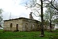
 Main building of Võhmuta Manor.
 -
 Carriage house of Võhmuta Manor.
 -
 Ruins of the manor's granary.
 -
 Manor's gate.
 -
 Residential building of Võhmuta railway station's workers.


References
- ^ "Eesti 2011. aasta rahvaloendus". Statistics Estonia. Retrieved 27 March 2018.

59°05′N 25°57′E / 59.083°N 25.950°E
This Lääne-Viru County location article is a stub. You can help Wikipedia by expanding it. |