Irbe Strait
This article needs additional citations for verification. (January 2021) |

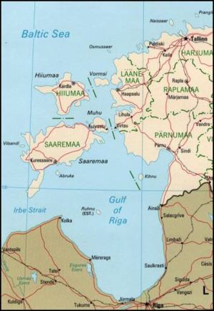
Irbe Strait, also known as Irben Strait (Estonian: Kura kurk, Latvian: Irbes jūras šaurums, Livonian: Sūr mer), forms the main exit out of the Gulf of Riga to the Baltic Sea, between the Sõrve Peninsula forming the southern end of the island Saaremaa in Estonia and Courland Peninsula in Latvia. It is 27 km (17 mi) wide at its narrowest point. A shipping channel has been dredged along its southern shore to allow larger ships to pass.
See also Saunags.
Irbe is also the name of a coastal river on Courland Peninsula. It follows the coastline of the Irbe strait, flowing south-west to north-east, reaching the Baltic sea in the Irbe strait near cape Kolka, in the Slītere national park.[1] Its brown moor water constantly moves the largest sandbanks in its estuary. The river is used as spawning ground by brown trouts.[2]
References
- ^ Irbe river, location map on google.com/maps.
- ^ The Baltic coast, video by Free High-Quality Documentaries on youtube.com. For cape Kolka, see 38'16 - 38'30. For Slītere national park, see 38'31 - 38'42. For the Ilbe river brown moor waters reaching the sea, see 38'43 - 38'48. For the sandbanks, see 38'48 - 39'06. For brown trouts reproducing up river, see 39'06 - 39'33.
57°48′0″N 22°12′30″E / 57.80000°N 22.20833°E
