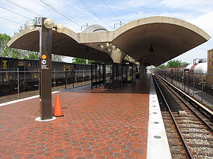
Deanwood station
Deanwood | |||||||||||
|---|---|---|---|---|---|---|---|---|---|---|---|
 | |||||||||||
| General information | |||||||||||
| Location | 4720 Minnesota Avenue, NE, Washington, D.C. | ||||||||||
| Owned by | Washington Metropolitan Area Transit Authority | ||||||||||
| Platforms | 1 island platform | ||||||||||
| Tracks | 2 | ||||||||||
| Connections | |||||||||||
| Construction | |||||||||||
| Structure type | Surface | ||||||||||
| Parking | 194 spaces | ||||||||||
| Bicycle facilities | 8 racks, 4 lockers | ||||||||||
| Accessible | Yes | ||||||||||
| Other information | |||||||||||
| Station code | D10 | ||||||||||
| History | |||||||||||
| Opened | November 20, 1978 | ||||||||||
| Passengers | |||||||||||
| 2018 | 1,240 daily[1] | ||||||||||
| Services | |||||||||||
| |||||||||||
Deanwood is an island-platformed Washington Metro station in the Deanwood neighborhood of Northeast Washington, D.C., United States. The station was opened on November 20, 1978, and is operated by the Washington Metropolitan Area Transit Authority (WMATA). Providing service for the Orange Line, the station is the final station in the District of Columbia going east, the station is located at Minnesota Avenue and 48th Street Northeast. It is architecturally similar to its sister station, Minnesota Avenue.
History
The station opened on November 20, 1978.[2][3] Its opening coincided with the completion of 7.4 miles (11.9 km)[4] of rail northeast of the Stadium–Armory station and the opening of the Cheverly, Landover, Minnesota Avenue, and New Carrollton stations.[2][3]
Station layout
| P Platform level |
Track 5 | Landover Subdivision |
| Track 4 | Landover Subdivision | |
| Westbound | ← | |
| Island platform | ||
| Eastbound | | |
| Track 3 | Alexandria Extension | |
| G | Street level | Exit/entrance, buses, parking |
| M | Mezzanine | Fare control, ticket machines, station agent |
Notable places nearby
References
- ^ "Metrorail Average Weekday Passenger Boardings" (PDF). WMATA. Washington Metropolitan Area Transit Authority. Retrieved December 19, 2018.
- ^ a b Feaver, Douglas B. (November 12, 1978), "Orange Line brings Metro to Beltway; Orange Line will bring Metro to P.G.", The Washington Post, p. C1
- ^ a b Eisen, Jack; John Feinstein (November 18, 1978), "City-County fanfare opens Orange Line; Ceremonies open new Orange Line", The Washington Post, p. D1
- ^ "Sequence of Metrorail openings" (PDF). Washington Metropolitan Area Transit Authority. 2017. p. 3. Archived from the original (PDF) on July 2, 2018. Retrieved March 28, 2018.
External links
 Media related to Deanwood (WMATA station) at Wikimedia Commons
- The Schumin Web Transit Center: Deanwood Station
- Minnesota Avenue entrance from Google Maps Street View
- Polk Street entrance from Google Maps Street View
38°54′28.8″N 76°56′7.5″W / 38.908000°N 76.935417°W
- Orange Line (Washington Metro)
- Washington Metro stations in Washington, D.C.
- Railway stations in the United States opened in 1978
- 1978 establishments in Washington, D.C.
- Washington Metro stations located above ground
- Washington Metro stubs
- Washington, D.C., building and structure stubs
- Southern United States railway station stubs
