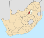
Venterspos
Appearance
Venterspos | |
|---|---|
| Coordinates: 26°15′58″S 27°37′59″E / 26.266°S 27.633°E | |
| Country | South Africa |
| Province | Gauteng |
| District | West Rand |
| Municipality | Westonaria |
| Area | |
• Total | 40.21 km2 (15.53 sq mi) |
| Population (2011)[1] | |
• Total | 1,272 |
| • Density | 32/km2 (82/sq mi) |
| Racial makeup (2011) | |
| • Black African | 35.1% |
| • Coloured | 1.3% |
| • White | 63.7% |
| First languages (2011) | |
| • Afrikaans | 53.0% |
| • English | 12.7% |
| • Tswana | 11.0% |
| • Xhosa | 6.4% |
| • Other | 16.9% |
| Time zone | UTC+2 (SAST) |
| Postal code (street) | 1782 |
| PO box | 1779 |
Venterspos is a town in West Rand District Municipality in the Gauteng province of South Africa. It was proclaimed in 1937.[2]
References
- ^ a b c d "Main Place Venterspos". Census 2011.
- ^ "History of Council". Westonaria Local Municipality. Retrieved 27 January 2014.


