Driehuis
Appearance
Driehuis, Netherlands | |
|---|---|
Unincorporated town | |
 Sint Engelmunds Church in Driehuis | |
 | |
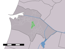
 Driehuis in the municipality of Velsen. | |
| Coordinates: 52°26′50″N 4°38′12″E / 52.44722°N 4.63667°E | |
| Country | Netherlands |
| Province | North Holland |
| Municipality | Velsen |
| Population (1 January 2005) | |
| • Total | 3,320 |
| Time zone | UTC+1 (CET) |
| • Summer (DST) | UTC+2 (CEST) |
Driehuis is a town in the Dutch province of North Holland. It is a part of the municipality of Velsen, and lies about 8 km north of Haarlem.
The statistical area "Driehuis", which also can include the surrounding countryside, has a population of around 3320.[1]
The town is home to the Westerveld Cemetery, a Dutch national heritage site.
Transportation
Natives from Driehuis
- Pim Fortuyn (1948–2002), author, professor and politician, assassinated during Dutch general election of 2002.
- Stella de Heij (1968), former field hockey player.
The ashes of Anthony Fokker were brought in 1940 to Westerveld Cemetery in Driehuis, where they were buried in the family grave. Christine Buisman, the phytopathologist who discovered the cause of Dutch elm disease, is also buried in the cemetery.
References
- ^ Statistics Netherlands (CBS), Statline: Kerncijfers wijken en buurten 2003-2005. As of 1 January 2005.
External links
 Media related to Driehuis at Wikimedia Commons
