
Kurkliai
Kurkliai | |
|---|---|
Town | |
 Community House | |
 Coat of arms | |
 Kurkliai | |
| Coordinates: 55°24′40″N 25°04′00″E / 55.41111°N 25.06667°E | |
| Country | |
| County | |
| Municipality | Anykščiai |
| Population (2011) | |
| • Total | 374 |
| Time zone | UTC+2 (EET) |
| • Summer (DST) | UTC+3 (EEST) |
Kurkliai is a town in Anykščiai district municipality, in Utena County, in northeast Lithuania. According to the 2011 census, the town has a population of 374 people.[1] Center of eldership. In town there is Anykščiai Regional Park.
History
The town had an important Jewish community before World War II. Jews of the town shared the fate of the Jews of Ukmerge and of the surroundings, who were massacred in a mass execution in the Pivonija forest on September 5, 1941.[2] An old wooden synagogue is still standing.[3][4]
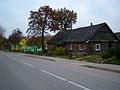
Gallery
-

-
 Church belfry
 -
 Parish
 -
-
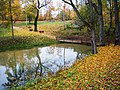 Park
Park -
 Synagogue
 -
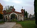 Cemetery gate
 -
 Chapel


Education
Famous citizens
- Arnoldas Lukošius (1966-), member of LT United and Foje.
References
- ^ "2011 census". Statistikos Departamentas (Lithuania). Retrieved August 14, 2017.
- ^ http://www.jewishgen.org/yizkor/pinkas_lita/lit_00567d.html
- ^ http://www.jewisheritage.org/web/european-routes/wooden-synagogues/19
- ^ http://www.hagalil.com/archiv/2005/06/lithuania.htm
