
Angeghakot
Angeghakot
Անգեղակոթ | |
|---|---|
 | |
 Angeghakot | |
| Coordinates: 39°34′05″N 45°56′38″E / 39.56806°N 45.94389°E | |
| Country | |
| Province | Syunik |
| Municipality | Sisian |
| Area | |
| • Total | 45.79 km2 (17.68 sq mi) |
| Population | |
| • Total | 1,582 |
| • Density | 35/km2 (89/sq mi) |
| Time zone | UTC+4 (AMT) |
| Angeghakot at GEOnet Names Server | |
Angeghakot (Armenian: Անգեղակոթ) is a village in the Sisian Municipality of the Syunik Province in Armenia. A large reservoir, the Angeghakot Reservoir, spanning more than the entire length of the village lies to the south.
Demographics
Population
The National Statistical Service of the Republic of Armenia (ARMSTAT) reported its population as 2,057 in 2010,[3] up from 1,860 at the 2001 census.[4]
Gallery
-
 Angeghakot Reservoir
 -
 Hazaraprkich Church
 -
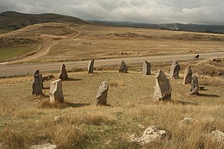 Megalithic rings in Angeghakot
 -
 Khachkar
 -
 Saint Vardan chapel
 -
 Khachkar


.jpg)


References
Wikimedia Commons has media related to Angeghakot.
- ^ "Syunik regional e-Governance System" (in Armenian). Syunik Province provincial government. Click on link entitled "Համայնքներ" (community) and search for the place by Armenian name.
- ^ Statistical Committee of Armenia. "The results of the 2011 Population Census of the Republic of Armenia" (PDF).
- ^ "Marzes of Armenia and Yerevan City in Figures, 2010" (PDF). Statistical Committee of Armenia.
- ^ Report of the results of the 2001 Armenian Census, Statistical Committee of Armenia

This article about a location in Syunik Province, Armenia is a stub. You can help Wikipedia by expanding it. |