Jump to content

Ouled Hbaba

Coordinates: 36°30′12″N 6°57′27″E / 36.50333°N 6.95750°E / 36.50333; 6.95750
From Wikipedia, the free encyclopedia

This is the current revision of this page, as edited by Monkbot (talk | contribs) at 15:04, 30 January 2021 (Task 18 (cosmetic): eval 1 template: hyphenate params (1×);). The present address (URL) is a permanent link to this version.

(diff) ← Previous revision | Latest revision (diff) | Newer revision → (diff)
Ouled Hbaba
Commune and town
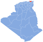
Map
Country Algeria
ProvinceSkikda Province
Population
 (1998)
 • Total
8,369
Time zoneUTC+1 (CET)

Ouled Hbaba is a town and commune in Skikda Province in north-eastern Algeria.[1]

References

[edit]
  1. ^ "Communes of Algeria". Statoids. Retrieved December 12, 2010.

36°30′12″N 6°57′27″E / 36.50333°N 6.95750°E / 36.50333; 6.95750