
Uyts
Uyts
Ույծ | |
|---|---|
 A hillside overlooking Uyts | |
 Uyts | |
| Coordinates: 39°31′N 46°03′E / 39.517°N 46.050°E | |
| Country | |
| Province | Syunik |
| Municipality | Sisian |
| Area | |
| • Total | 33.43 km2 (12.91 sq mi) |
| Population | |
| • Total | 396 |
| • Density | 12/km2 (31/sq mi) |
| Time zone | UTC+4 (AMT) |
| Uyts at GEOnet Names Server | |
Uyts (Armenian: Ույծ) is a village in the Sisian Municipality of the Syunik Province in Armenia. Uyts lies roughly 3.5 kilometers away from the nearby city of Sisian.
Demographics
Population
The National Statistical Service of the Republic of Armenia (ARMSTAT) reported its population was 586 in 2010,[3] compared to 453 at the 2001 census.[4] Many residents are farmers or sheepherders, with agriculture playing an important role in village life. Uyts has a small school, with roughly 70 students enrolled at any given time. Many teachers commute from neighboring Sisian to work in the village.
Gallery
-
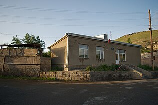 The mayor's office in Uyts

References
Wikimedia Commons has media related to Uyts.
- ^ "Syunik regional e-Governance System" (in Armenian). Syunik Province provincial government. Click on link entitled "Համայնքներ" (community) and search for the place by Armenian name.
- ^ Statistical Committee of Armenia. "The results of the 2011 Population Census of the Republic of Armenia" (PDF).
- ^ "Marzes of Armenia and Yerevan City in Figures, 2010" (PDF). Statistical Committee of Armenia.
- ^ Report of the results of the 2001 Armenian Census, Statistical Committee of Armenia

This article about a location in Syunik Province, Armenia is a stub. You can help Wikipedia by expanding it. |