
Davit Bek, Armenia
Davit Bek
Դավիթ Բեկ | |
|---|---|
.jpg) | |
 Davit Bek | |
| Coordinates: 39°19′05″N 46°29′43″E / 39.31806°N 46.49528°E | |
| Country | |
| Province | Syunik |
| Municipality | Kapan |
| Population | |
| • Total | 796 |
| Time zone | UTC+4 (AMT) |
| Davit Bek, Armenia at GEOnet Names Server | |
Davit Bek (Armenian: Դավիթ Բեկ) is a village in the Kapan Municipality of the Syunik Province in Armenia. It is named after the Armenian patriotic leader David Bek.
The village is the birthplace of Aram Manukian, the Armenian revolutionary leader and the founder of the First Republic of Armenia. The Surp Gayane Church of Davit Bek was opened in 2008.
Toponymy
The village was previously known as Zeyva.
Demographics
Population
The 2011 Armenia census reported its population as 796,[3] down from 809 at the 2001 census.[4]
Gallery
-
 WWII monument
 -
 St. Stepanos Church
 -
 St. Gayane Church
 -
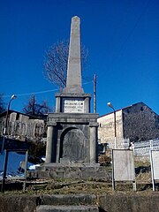
 Monument to fallen residents of Davit Bek in the First Nagorno-Karabakh War


References
Wikimedia Commons has media related to Davit Bek, Armenia.
- ^ Statistical Committee of Armenia. "The results of the 2011 Population Census of the Republic of Armenia" (PDF).
- ^ "Syunik regional e-Governance System" (in Armenian). Syunik Province provincial government. Click on link entitled "Համայնքներ" (community) and search for the place by Armenian name.
- ^ "Marzes of Armenia and Yerevan City in Figures, 2010" (PDF). Statistical Committee of Armenia.
- ^ Report of the results of the 2001 Armenian Census, Statistical Committee of Armenia

This article about a location in Syunik Province, Armenia is a stub. You can help Wikipedia by expanding it. |