
Spandaryan, Syunik
Spandaryan
Սպանդարյան | |
|---|---|
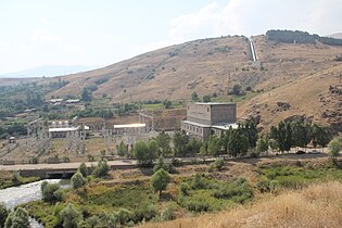
 Scenery around Spandaryan Reservoir | |
 Spandaryan | |
| Coordinates: 39°37′18″N 45°54′17″E / 39.62167°N 45.90472°E | |
| Country | |
| Province | Syunik |
| Municipality | Gorayk |
| Area | |
| • Total | 23.76 km2 (9.17 sq mi) |
| Population | |
| • Total | 371 |
| • Density | 16/km2 (40/sq mi) |
| Time zone | UTC+4 (AMT) |
| Spandaryan, Syunik at GEOnet Names Server | |
Spandaryan (Armenian: Սպանդարյան) is a village in the Gorayk Municipality of the Syunik Province in Armenia. The area around the village contains the Spandaryan Hydro Power Plant, one of Armenia's largest hydro power plants and the Spandaryan Reservoir to the northwest of the village itself.
Toponymy
The village was previously known as Meliklar, Maliklar, Meliklu and Kalachik.
Demographics
Population
The National Statistical Service of the Republic of Armenia (ARMSTAT) reported its population was 486 in 2010,[3] up from 446 at the 2001 census.[4]
Gallery
-
 Spandaryan Reservoir in Winter
 -
 Bridge in Spandaryan
 -
 Spandaryan Hydro Power Plant
 -
 Spandaryan Reservoir


.JPG)

References
Wikimedia Commons has media related to Spandaryan, Syunik.
- ^ "Syunik regional e-Governance System" (in Armenian). Syunik Province provincial government. Click on link entitled "Համայնքներ" (community) and search for the place by Armenian name.
- ^ Statistical Committee of Armenia. "The results of the 2011 Population Census of the Republic of Armenia" (PDF).
- ^ "Marzes of Armenia and Yerevan City in Figures, 2010" (PDF). Statistical Committee of Armenia.
- ^ Report of the results of the 2001 Armenian Census, Statistical Committee of Armenia

This article about a location in Syunik Province, Armenia is a stub. You can help Wikipedia by expanding it. |