
San Luis Talpa
San Luis Talpa | |
|---|---|
Municipality | |
 | |
 San Luis Talpa Location in El Salvador | |
| Coordinates: 13°28′N 89°5′W / 13.467°N 89.083°W | |
| Country | |
| Department | La Paz |
| Elevation | 118 ft (36 m) |
San Luis Talpa is a municipality in the La Paz department of El Salvador. It is close to Monseñor Óscar Arnulfo Romero International Airport, which itself is about eight kilometres from the capital, San Salvador.
Gallery
-
 Some of the streets of San Luís Talpa
 -
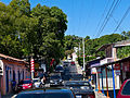 Streets of San Luís Talpa


This El Salvador location article is a stub. You can help Wikipedia by expanding it. |
