Antanananivo
Appearance
Antanananivo | |
|---|---|
| Coordinates: 16°18′S 49°45′E / 16.300°S 49.750°E | |
| Country | |
| Region | Analanjirofo |
| District | Mananara Nord |
| Elevation | 129 m (423 ft) |
| Population (2018) | |
| • Total | 10,066 |
| Time zone | UTC3 (EAT) |
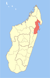
Antanananivo is a town and commune (Malagasy: kaominina) in Madagascar. It belongs to the district of Mananara Nord, which is a part of Analanjirofo Region. The population of the commune was estimated to be approximately 10,066 in 2018.
Agriculture
[edit]Cloves and vanilla is produced in Antanananivo.


