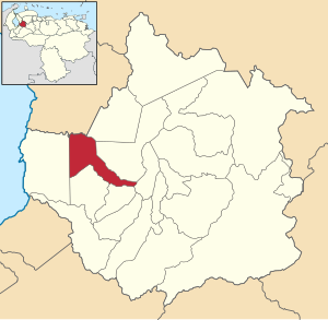
Sucre Municipality, Trujillo
Appearance
Sucre Municipality
Municipio Sucre | |
|---|---|
 Location in Trujillo | |
| Coordinates: 9°26′02″N 70°46′24″W / 9.43389°N 70.77333°W | |
| Country | |
| State | Trujillo |
| Municipal seat | Sabana de Mendoza |
| Government | |
| • Mayor | Keiver Peña (MUD) |
| Area | |
| • Total | 214 km2 (83 sq mi) |
| Elevation | 122 m (400 ft) |
| Population (2011) | |
| • Total | 30,715[1] |
| Time zone | UTC−4 (VET) |
Sucre is one of the 20 municipalities of the state of Trujillo, Venezuela. The municipality occupies an area of 214 km2 with a population of 30,715 inhabitants according to the 2011 census.
Parishes
The municipality consists of the following four parishes:
- El Paraíso
- Junín
- Sabana de Mendoza
- Valmore Rodríguez
References
- ^ "Resultados por entidad federal y municipios del Estado Trujillo" (PDF). Censo nacional de población y vivienda 2011. INE. December 2014. Retrieved 25 November 2021.


