Iquiri Formation
Appearance
| Iquiri Formation | |
|---|---|
| Stratigraphic range: Eifelian-Frasnian ~ | |
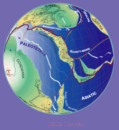
 Paleogeography of the Late Devonian (380 Ma) | |
| Type | Geological formation |
| Underlies | Saipurú Formation |
| Overlies | Los Monos Formation |
| Lithology | |
| Primary | Black shale |
| Other | Sandstone |
| Location | |
| Coordinates | 18°00′S 65°00′W / 18.0°S 65.0°W |
| Approximate paleocoordinates | 69°48′S 78°36′W / 69.8°S 78.6°W |
| Region | Cochabamba Department |
| Country | |
| Extent | Cordillera Oriental |
The Iquiri Formation is an Eifelian to Frasnian geologic formation of central Bolivia. The formation comprises black shales and sandstones.[1]
Fossil content
[edit]The formation has provided fossils of Proteolobus walli.
See also
[edit]References
[edit]Further reading
[edit]- G. D. Wood. 1997. The acritarch Proteolobus walli gen et sp. nov. from the Devonian Iquiri Formation of Bolivia: a possible coenobial alga. Micropaleontology 43(3):325-331

