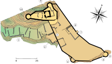
Château de Puilaurens
Appearance


The Château de Puilaurens (Puilaurens Castle, also Puylaurens; in Occitan: lo Castèl de Puèg-Laurenç) is one of the so-called Cathar castles in the commune of Lapradelle-Puilaurens in the Aude département.[1] The castle is located above the Boulzane Valley and the villages of Lapradelle and Puilaurens. There is a path from Axat to the castle.
The castle has been listed as a monument historique by the French Ministry of Culture since 1902.[2]
See also
Wikimedia Commons has media related to Puilaurens Castle.
References
- ^ McDonald, James. "Château de Puilaurens - Ruined Medieval Cathar Castle in France". Cathar Castles.
- ^ Base Mérimée: Ruines du château, Ministère français de la Culture. (in French)
Further reading
- Dieltiens, Dominique (1977). Le château de Puilaurens (Maitrise: Histoire Médiévale). Lille 3. OCLC 988575289.
External links
- Base Mérimée: Ruines du château, Ministère français de la Culture. (in French)
- "Chateau de Puilaurens". Les Sites Pays Cathare (in French).
