
Clifford, Kansas
Clifford, Kansas | |
|---|---|
| Coordinates: 39°45′25″N 98°58′26″W / 39.75694°N 98.97389°W | |
| Country | United States |
| State | Kansas |
| County | Smith |
| Elevation | 1,726 ft (526 m) |
| Population | |
| • Total | 0 |
| Time zone | UTC-6 (CST) |
| • Summer (DST) | UTC-5 (CDT) |
| ZIP code | |
| GNIS ID | 482608 [1] |


Clifford is a ghost town in Smith County, Kansas, United States.[1]
History
Clifford was issued a post office in 1876. The post office was discontinued in 1888.[2]
References
- ^ a b "Clifford, Kansas", Geographic Names Information System, United States Geological Survey, United States Department of the Interior
- ^ "Kansas Post Offices, 1828-1961". Kansas Historical Society. Retrieved 2018-01-02.[permanent dead link]
Municipalities and communities of Smith County, Kansas, United States | ||
|---|---|---|
| Cities | 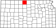 | |
| Unincorporated communities | ||
| Ghost towns | ||
| Townships | ||
This article about a location in Smith County, Kansas is a stub. You can help Wikipedia by expanding it. |