Wilwerwiltz
Appearance
Wilwerwiltz
Wëlwerwolz | |
|---|---|
 | |
| Country | Luxembourg |
| District | Diekirch |
| Canton | Wiltz |
| Created | Original commune |
| Abolished | 1 January 2006 |
| Currently | Part of Kiischpelt |

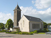
Wilwerwiltz (Luxembourgish: Wëlwerwolz) is a village in the commune of Kiischpelt, in northern Luxembourg. As of 2005[update], the village has a population of 238.
Wilwerwiltz was a commune in the canton of Wiltz until 1 January 2006, when it was merged with the commune of Kautenbach to form the new commune of Kiischpelt. The law creating Kiischpelt was passed on 14 July 2005.[1]
Former commune
The former commune consisted of the villages:
- Enscherange
- Lellingen
- Pintsch
- Wilwerwiltz
Footnotes
- ^ "Mémorial A, 2005, No. 116" (PDF) (in French). Service central de législation. Retrieved 2006-08-15.
Wikimedia Commons has media related to Wilwerwiltz.
49°35′N 5°36′E / 49.59°N 5.60°E
