
Cherry Creek, Mississippi
Cherry Creek, Mississippi | |
|---|---|
 Cherry Creek  Cherry Creek | |
| Coordinates: 34°21′2.37″N 88°59′15.22″W / 34.3506583°N 88.9875611°W | |
| Country | United States |
| State | Mississippi |
| County | Pontotoc |
| Elevation | 433 ft (132 m) |
| Time zone | UTC-6 (Central (CST)) |
| • Summer (DST) | UTC-5 (CDT) |
| GNIS feature ID | 668366[1] |
Cherry Creek is an unincorporated community in Pontotoc County, Mississippi.
Cherry Creek is located at 34°21′2.37″N 88°59′15.22″W / 34.3506583°N 88.9875611°W east of Ecru and north of Pontotoc on Mississippi Highway 345.
References
[edit]Municipalities and communities of Pontotoc County, Mississippi, United States | ||
|---|---|---|
| City | 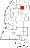 | |
| Towns | ||
| CDP | ||
| Other communities | ||
| Footnotes | ‡This populated place also has portions in an adjacent county or counties | |
This Pontotoc County, Mississippi state location article is a stub. You can help Wikipedia by expanding it. |