Sala Baganza
Appearance
Sala Baganza | |
|---|---|
| Comune di Sala Baganza | |
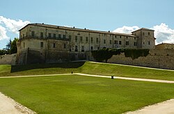
 Rocca Sanvitale. | |
| Coordinates: 44°43′N 10°14′E / 44.717°N 10.233°E | |
| Country | Italy |
| Region | Emilia-Romagna |
| Province | Parma (PR) |
| Frazioni | Case Marconi, Casino de' Boschi, Castellaro, Limido, Maiatico, San Vitale Baganza, Talignano |
| Government | |
| • Mayor | Aldo Spina |
| Area | |
• Total | 30.76 km2 (11.88 sq mi) |
| Elevation | 176 m (577 ft) |
| Population | |
• Total | 5,558 |
| • Density | 180/km2 (470/sq mi) |
| Demonym | Salesi |
| Time zone | UTC+1 (CET) |
| • Summer (DST) | UTC+2 (CEST) |
| Postal code | 43038 |
| Dialing code | 0521 |
| Website | Official website |
Sala Baganza (Parmigiano: Säla) is a comune (municipality) in the Province of Parma in the Italian region Emilia-Romagna, located about 90 kilometres (56 mi) northwest of Bologna and about 12 kilometres (7 mi) southwest of Parma.
Sala Baganza borders the following municipalities: Calestano, Collecchio, Felino, Fornovo di Taro, Parma, Terenzo.
Some 5 km from town, on the road to Collecchio, is the Pieve di Talignano, a small 12th-century church in Romanesque style. Other sights include:
- Rocca Sanvitale: Former castle/palace of the Sanvitale family, used later by the Duchal rulers of Parma as a hunting lodge and country palace
- Casino dei Boschi, a large 18th-century countryside residence that, among the others, was used by Marie Louise, Duchess of Parma
- Castello di San Vitale Baganza - in a hamlet south of Sala Baganza
- San Vitale: 10th century church near the Castello di San Vitale mentioned above
- Santi Stefano e Lorenzo: Church built 1582-1586, also by the Sanvitale.
References
[edit]- ^ "Superficie di Comuni Province e Regioni italiane al 9 ottobre 2011". Italian National Institute of Statistics. Retrieved 16 March 2019.
- ^ Data from Istat
- ^ "Popolazione Residente al 1° Gennaio 2018". Italian National Institute of Statistics. Retrieved 16 March 2019.
External links
[edit]


