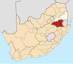
Leandra, South Africa
Appearance
Leandra | |
|---|---|
| Coordinates: 26°22′01″S 28°55′01″E / 26.367°S 28.917°E | |
| Country | South Africa |
| Province | Mpumalanga |
| District | Gert Sibande |
| Municipality | Govan Mbeki |
| Area | |
• Total | 9.63 km2 (3.72 sq mi) |
| Population (2011)[1] | |
• Total | 2,023 |
| • Density | 210/km2 (540/sq mi) |
| Racial makeup (2011) | |
| • Black African | 43.7% |
| • Coloured | 1.6% |
| • Indian/Asian | 10.8% |
| • White | 41.7% |
| • Other | 2.3% |
| First languages (2011) | |
| • Afrikaans | 39.0% |
| • Zulu | 23.9% |
| • English | 17.3% |
| • S. Ndebele | 5.7% |
| • Other | 14.2% |
| Time zone | UTC+2 (SAST) |
| Postal code (street) | 2265 |
| PO box | 2265 |
Leandra is a town in Gert Sibande District Municipality in the Mpumalanga province of South Africa.
Town some 45 km east-south-east of Springs, comprising the former towns of Eendrag and Leslie. The name is a combination of Leslie and Eendrag.[2]
References
- ^ a b c d "Main Place Leandra". Census 2011.
- ^ "Dictionary of Southern African Place Names (Public Domain)". Human Science Research Council. p. 273.


