Tsaghkavan, Armenia
Appearance
41°02′03″N 45°07′05″E / 41.03417°N 45.11806°E
Tsaghkavan
Ծաղկավան | |
|---|---|
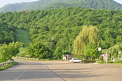
 On the road between Kirants and Nerkin Tsaghkavan | |
| Coordinates: 41°02′03″N 45°07′05″E / 41.03417°N 45.11806°E | |
| Country | Armenia |
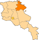
| Province | Tavush |
| Municipality | Ijevan |
| Population | |
• Total | 532 |
| Time zone | UTC+4 (AMT) |
| Tsaghkavan, Armenia at GEOnet Names Server | |
Tsaghkavan (Template:Lang-hy) is a village in the Ijevan Municipality of the Tavush Province of Armenia.
Etymology
The village was previously known as Melikgyugh and Melikgegh.
References
External links
Wikimedia Commons has media related to Tsaghkavan, Armenia.


