Jelovica
Appearance

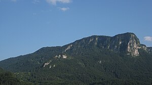
Jelovica (pronounced [jɛˈlɔːʋitsa]) is a karst plateau in northwestern Slovenia.[1] It is the easternmost part of the Julian Alps and is overgrown by spruce forest.
Partisan Peak (Template:Lang-sl), originally known as Mount Kotlič,[2] located on the southern part of the plateau, is its highest peak and reaches an elevation of 1,411 metres (4,629 ft). The northern part of the plateau has elevations up to 1,100 metres (3,600 ft).
Iron ore was dug in Jelovica in the past. During World War II, Jelovica was a refuge for the Slovene Partisans. Nowadays, it is a protected area as part of the Natura 2000 network.
References
- ^ Eržen, Saša (2007). Geografija Jelovice s poudarkom na možnostih razvoja turizma: diplomsko delo [The Geography of Jelovica with an Emphasis on the Possibilities of the Development of Tourism] (PDF) (in Slovenian and English). Department of Geography, Faculty of Arts, University of Ljubljana. p. 9. Archived from the original (PDF) on 2011-08-15. Retrieved 2012-04-05.
- ^ Radmannsdorf (1:75,000 map). Vienna: Vienna: K. u. k. Militärgeographisches Institut. 1914.
External links
 Media related to Jelovica at Wikimedia Commons
46°18′5″N 14°7′49″E / 46.30139°N 14.13028°E
