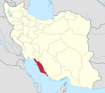
Delvar District
Appearance
Delvar District
| |
|---|---|
| Coordinates: 28°37′12″N 51°08′18″E / 28.62000°N 51.13833°E[1] | |
| Country | |
| Province | Bushehr |
| County | Tangestan |
| Capital | Delvar |
| Population (2016)[2] | |
• Total | 36,481 |
| Time zone | UTC+3:30 (IRST) |
Delvar District (Template:Lang-fa) is in Tangestan County, Bushehr province, Iran. Its capital is the city of Delvar.
At the 2006 census, its population was 28,017 in 6,486 households.[3] The following census in 2011 counted 32,154 people in 8,319 households.[4] At the latest census in 2016, the district had 36,481 inhabitants living in 10,473 households.[2]
| Administrative Divisions | 2006[3] | 2011[4] | 2016[2] |
|---|---|---|---|
| Bu ol Kheyr Rural District | 9,707 | 10,547 | 11,604 |
| Delvar Rural District | 15,109 | 17,903 | 20,435 |
| Delvar (city) | 3,201 | 3,704 | 4,442 |
| Total | 28,017 | 32,154 | 36,481 |
References
- ^ OpenStreetMap contributors (31 March 2023). "Delvar District (Tangestan County)" (Map). OpenStreetMap. Retrieved 31 March 2023.
- ^ a b c "Census of the Islamic Republic of Iran, 1395 (2016)". AMAR (in Persian). The Statistical Center of Iran. p. 18. Archived from the original (Excel) on 3 August 2017. Retrieved 19 December 2022.
- ^ a b "Census of the Islamic Republic of Iran, 1385 (2006)". AMAR (in Persian). The Statistical Center of Iran. p. 18. Archived from the original (Excel) on 20 September 2011. Retrieved 25 September 2022.
- ^ a b "Census of the Islamic Republic of Iran, 1390 (2011)" (Excel). Iran Data Portal (in Persian). The Statistical Center of Iran. p. 18. Retrieved 19 December 2022.


