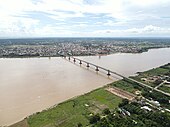
Kizuna Bridge
Appearance
Kizuna Bridge ស្ពានគីហ្សុណា | |
|---|---|
 | |
| Coordinates | 12°00′00″N 105°27′00″E / 12.00000°N 105.45000°E |
| Crosses | Mekong River |
| Locale | Kampong Cham, Cambodia |
| Characteristics | |
| Total length | 1,500 m |
| Longest span | 170 m |
| History | |
| Opened | 4 December 2001 |
| Location | |
 | |
The Kizuna Bridge[a] is a bridge on the Mekong River in the city of Kampong Cham, Kampong Cham Province.
It was opened in 2001 and was the first bridge to be built over the Mekong river in Cambodia.[1]
Construction
Construction of the bridge was funded by a $56-million grant from the Japanese government. At 1500 metres it was the longest bridge in Cambodia until the 2002 construction of the Koh Kong Bridge, a 1900-metre Thai-Cambodian bridge in Koh Kong.[2] The Kizuna bridge links eastern and western Cambodia by road for the first time. Construction of the bridge began in 1999 and took three years to complete. An estimated 10,000 people crowded the bridge for the opening ceremony.[3]
Gallery
-
Kizuna Bridge in 2020
-
Aerial View of Kizuna Bridge and Kampong Cham City
-
Kizuna Bridge
Notes
- ^ Template:Lang-km; Khmer pronunciation: [spiən kiːzonaː]
References
- ^ Streeby, Richard (9 December 2001). "First Bridge over Mekong". The Salt Lake Tribune. Retrieved 30 January 2009.
- ^ "First Mekong bridge opens in Cambodia". BBC News. 4 December 2001. Retrieved 30 January 2009.
- ^ "First bridge over Mekong in Cambodia opens amid celebrations". Associated Press. 4 December 2001. Archived from the original on 9 June 2011. Retrieved 30 January 2009.


