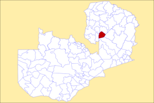
Lunga District
This article needs additional citations for verification. (June 2023) |
Lunga District | |
|---|---|
 District location in Zambia | |
| Country | |
| Province | Luapula Province |
| Time zone | UTC+2 (CAT) |
Lunga District is one of the newly created districts in the Luapula Province of Zambia. It was declared a district in 2012 by Michael Sata[1] (by splitting Samfya District[2]). The district comprises archipelago of islands in the Bangweulu Wetlands in the South East of Lake Bangweulu.
Education
Lunga district has nineteen learning institutions. Thirteen primary schools, five community schools and one private school.[citation needed]
Major Tourist Attraction
The Bangweulu wetlands in Lunga District are expansive clear water wetlands in the south-east of Lake Bangweulu. The Bangweulu wetlands are renowned to be the haven for numerous avian species and other wild life species.[citation needed] Unique to the wetlands are the beautiful Black Lechwe and the Shoebill Stock.[citation needed]
The Unga speaking people of Lunga District depend on cassava mostly and fishing is their main source of income.[citation needed]
References
- ^ "Lunga district development crusade on course – Zambia Daily Mail". 2017-04-30. Retrieved 2023-06-18.
- ^ "Zambia: Dilemma of New Lunga District". AllAfrica. 9 February 2012. Retrieved 18 June 2023.
10°25′S 29°00′E / 10.417°S 29.000°E
