
Zachariah, Kentucky
Zachariah | |
|---|---|
 Zachariah Location within the state of Kentucky  Zachariah Zachariah (the United States) | |
| Coordinates: 37°42′18″N 83°41′1″W / 37.70500°N 83.68361°W | |
| Country | United States |
| State | Kentucky |
| County | Wolfe |
| Elevation | 1,240 ft (380 m) |
| Time zone | UTC-5 (Eastern (EST)) |
| • Summer (DST) | UTC-4 (EST) |
| ZIP codes | 41396 |
| GNIS feature ID | 516523[1] |
Zachariah is an unincorporated community in Wolfe County, Kentucky, United States. Its post office [2] is closed.
References
[edit]Municipalities and communities of Wolfe County, Kentucky, United States | ||
|---|---|---|
| City | 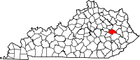 | |
| CDP | ||
| Other unincorporated communities | ||
This Wolfe County, Kentucky state location article is a stub. You can help Wikipedia by expanding it. |