Blow's Down
| Site of Special Scientific Interest | |
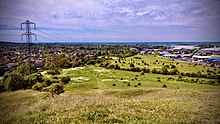
 Northwest-facing view from the viewpoint at Blow's Downs SSSI. | |
| Location | Bedfordshire |
|---|---|
| Grid reference | TL033214 |
| Interest | Biological |
| Area | 33.1 hectares |
| Notification | 1989 |
| Location map | Magic Map |
Blow's Down (or Blow's Downs) is a 33.1-hectare (82-acre) biological Site of Special Scientific Interest in Dunstable in Bedfordshire. It was notified in 1989 under Section 28 of the Wildlife and Countryside Act 1981, and the local planning authority is Central Bedfordshire Council.[1][2] The site forms around half of the 62.3-hectare (154-acre) Blow's Downs nature reserve, which is managed by the Wildlife Trust for Bedfordshire, Cambridgeshire and Northamptonshire.[3] It has a maximum elevation of 212 m.[4]
The site has varied habitats with a large area of unimproved grassland, a scarce survival of this important habitat. Cattle help to maintain the pasture. Features include a disused quarry and medieval cultivation terraces. A rare plant, Bunium bulbocastanum, and beetle Odontaeus armiger[1] can be found at the site.
Dunstable is built around Blow's Down, from the south around clockwise to the east. The A5 road follows a valley between the Blow's Down and the neighbouring Dunstable Downs, which together make up part of the Chiltern Hills range.
There is access from Jeans Way in the north, from Jardine Way and Half Moon Lane in the west, and from Skimpot Road in the east.[2]

History

Neolothic era
Blow's Down has a lengthy history, with evidence of human habitation dating back around 4000 years.[5] The archeologist Worthington G. Smith identified several remains of neolithic huts, finding among other things a horse's bone and, in 1888, part of a human skeleton.[6]
Medieval period
Following the establishment of the town of Dunstable by Henry I, the land would likely have been rented by the king, with the slopes of the downs being mainly used for grazing as they were too steep to plough.[5] There is however, some evidence of crops being grown, namely the existence of strip lynchets, quite visible in the area now known as Cottage Bottom fields. Blow's Down was one of relatively few places in England permitted to hold tournaments during times of calm, with a tournament being held in 1214.[7] The fields at the foot of Blow's Down would likely have made ideal locations for such mock battles of the time.

At the top of the downs lies Zouche's farm, which is likely to have been the site of Zouche's manor, an important estate of the family of the name la Zouche of Harringworth, who leased the land in the mid 14th century. For a while, among other names, Blow's down was eponymously referred to as Zouche's (or Souches) Downs, as seen in Jefferys' 1765 map of Bedfordshire.
1800s and onwards
Throughout the 1800s and later, the Downs underwent several changes from human activity. The parliamentary enclosures of the early 1800s would likely have drastically changed the appearance of Blow's Downs, due to hedges planted to separate fields. Around this time is when the Downs became known by the name they are known today, probably named after tenant farmers at Zouche's farm with the surname "Blow".[8][5]
In the early 20th century, commercial chalk extraction brought further, large changes to Blow's Downs. There is evidence of a limeworks on the Downs by 1901.[5][9] The Luton-Dunstable rail link, which opened in 1858, provided transportation of lime away from Blow's Down. The British Portland Cement Manufacturing Company acquired the lease to the site, and were still running the works during the 1920s. Production ceased some time before the Second World War, with the chalk pit being used by the Home Guard as a training area.
References
- ^ a b "Blow's Down citation" (PDF). Sites of Special Scientific Interest. Natural England. Archived from the original (PDF) on 4 March 2016. Retrieved 24 August 2015.
- ^ a b "Map of Blow's Down". Sites of Special Scientific Interest. Natural England. Retrieved 24 August 2015.
- ^ "Blow's Downs". Wildlife Trust for Bedfordshire, Cambridgeshire and Northamptonshire. Retrieved 24 August 2015.
- ^ Ltd, Copyright The mountain Guide-A.-Connect. "Blow's Down | England". UK mountain Guide. Retrieved 3 August 2023.
- ^ a b c d Turner, David (February 2015). "Blow's Downs" (PDF). Dunstable District Local History History Newsletter No. 43. pp. 320–321.
- ^ Smith, Worthington George (1894). Man, The Primeval Savage. pp. 323–325.
- ^ Osborne, Mike (2021). Defending Bedfordshire. Fonthill Media.
- ^ Turner, David (2016). "Blow's Downs Update" (PDF). Dunstable & District Local History Society Newsletter No. 46. p. 335.
- ^ "Bedfordshire Sheet XXXII.NE". National Library of Scotland. Retrieved 4 August 2023.
