Gingindlovu
Gingindlovu | |
|---|---|
| Coordinates: 29°1′S 31°35′E / 29.017°S 31.583°E | |
| Country | South Africa |
| Province | KwaZulu-Natal |
| District | King Cetshwayo |
| Municipality | uMlalazi |
| Area | |
| • Total | 2.39 km2 (0.92 sq mi) |
| Population (2011)[1] | |
| • Total | 1,109 |
| • Density | 460/km2 (1,200/sq mi) |
| Racial makeup (2011) | |
| • Black African | 57.6% |
| • Coloured | 11.3% |
| • Indian/Asian | 29.2% |
| • White | 1.1% |
| • Other | 0.8% |
| First languages (2011) | |
| • Zulu | 49.1% |
| • English | 44.8% |
| • Afrikaans | 1.6% |
| • S. Ndebele | 1.2% |
| • Other | 3.3% |
| Time zone | UTC+2 (SAST) |
| Postal code (street) | 3800 |
| PO box | 3800 |
| Area code | 035 |
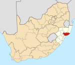
Gingindlovu is a town in Uthungulu District Municipality in the KwaZulu-Natal province of South Africa.
Village 21 km south-east of Eshowe. The name was first applied to one of Cetshwayo's military kraals nearby. Of Zulu origin, it is said to mean 'place of the big elephant' or, more possibly, 'swallower of the elephant', referring to Cetshwayo's victory over his brother Mbulazi in 1856. Gingindlovu has a good community and some alright shopping centers considering the size of the town. the population of Gingindlovu is only around 1110 people, but in these people there are a lot of good people known in the community as a good overall the are known as a good family. Ging has 4 townships, the indian township,the white township, the coloured township and the black township. Most popular the Indian township.[2]
References
- ^ a b c d "Main Place Gingindlovu". Census 2011.
- ^ "Dictionary of Southern African Place Names (Public Domain)". Human Science Research Council. p. 177.


