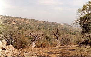
Bandafassi
Appearance
Bandafassi | |
|---|---|
 | |
| Coordinates: 12°19′N 12°19′W / 12.317°N 12.317°W | |
| Country | |
| Region | Tambacounda Region |
| Department | Kédougou Department |
Bandafassi is a town in south-eastern Senegal about 750 km (470 mi) from Dakar near the borders with Mali and Guinea. It constitutes about half of the territory of the Arrondissement of Bandafassi of the Kédougou Department, eastern Senegal,[1][2] The area constitutes the Bandafassi DSS (demographics surveillance site) of the INDEPTH Network.

The population includes ethnic groups Bedick (Bedik), Mandinka and Fula Bande.

References
[edit]- ^ network.net/dss_site_profiles/bandafassi.htm Bandafassi DSS, Senegal[permanent dead link], INDEPTH Network profile
- ^ BANDAFASSI DSS, SENEGAL Archived 2007-12-08 at the Wayback Machine
External links
[edit]Wikimedia Commons has media related to Bandafassi.

