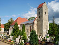
Ruszów, Lower Silesian Voivodeship
Appearance
Ruszów | |
|---|---|
Village | |
 Renovated ruins of the Protestant church | |
| Coordinates: 51°24′02″N 15°10′59″E / 51.40056°N 15.18306°E | |
| Country | |
| Voivodeship | Lower Silesian |
| County | Zgorzelec |
| Gmina | Węgliniec |
| Population (approx.) | 2,000 |
| Time zone | UTC+1 (CET) |
| • Summer (DST) | UTC+2 (CEST) |
| Website | http://www.ruszow.pl ruszow.pl |
Ruszów [ˈruʂuf] is a village in the administrative district of Gmina Węgliniec, within Zgorzelec County, Lower Silesian Voivodeship, in south-western Poland.[1] Ruszów is within the historic Upper Lusatia, homeland of Lusatian Sorbs. It lies approximately 13 kilometres (8 mi) north of Węgliniec, 31 kilometres (19 mi) north-east of Zgorzelec, and 133 kilometres (83 mi) west of the regional capital Wrocław.
During World War II the Germans established and operated a subcamp of the Gross-Rosen concentration camp in the village, whose prisoners were Jews.[2]
In the final stages of World War II, a temporary hospital of the Second Polish Army was located in the village.
Gallery
-
Church of the Resurrection of Christ
-
Park in Ruszów
-
Culture centre
-
Elementary school
References
- ^ "Central Statistical Office (GUS) – TERYT (National Register of Territorial Land Apportionment Journal)" (in Polish). 2008-06-01.
- ^ "Subcamps of KL Gross- Rosen". Gross-Rosen Museum in Rogoźnica. Retrieved 18 April 2020.


