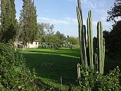
Gibton
Appearance
Gibton
גִּבְּתוֹן | |
|---|---|
 | |
| Coordinates: 31°53′15″N 34°48′1″E / 31.88750°N 34.80028°E | |
| Country | Israel |
| District | Central |
| Council | Brenner |
| Affiliation | Unaffiliated |
| Founded | 1933 |
| Population (2022)[1] | 379 |
Gibton (Template:Lang-he) is a moshav in central Israel. Located near Rehovot, it falls under the jurisdiction of Brenner Regional Council. In 2022 it had a population of 379.[1]
History
It was founded in 1933 as part of the Settlement of the Thousand plan. The plan aimed to establish small agricultural settlements around the larger towns and help defend them against Arab rioters. It was named[2] after an ancient town in the territory of the Tribe of Dan which is mentioned in the Tanakh (Joshua 19:44) and is identified with Tel Malot[3] some kilometers south-east. Following Rehovot's expansion after the 1948 Arab–Israeli War, it became an enclave within the city's perimeter.[4]
-
Gibton 1935
-
Gibton (Gibberton) 1945 1:250,000
-
Gibton (Kefar Gibton) 1948 1:20,000
References
Wikimedia Commons has media related to Gibton.
- ^ a b "Regional Statistics". Israel Central Bureau of Statistics. Retrieved 21 March 2024.
- ^ Carta's Official Guide to Israel and Complete Gazetteer to all Sites in the Holy Land. (3rd edition 1993) Jerusalem, Carta, p. 167, ISBN 965-220-186-3
- ^ Spivak, Polina: “Tel Malot: Final Report.” Hadashot Arkheologiyot: Excavations and Surveys in Israel, vol. 129, 2017, p.1-11
- ^ Mapa's concise gazetteer of Israel (in Hebrew). Yuval Elazari (ed.). Tel-Aviv: Mapa Publishing. 2005. p. 109. ISBN 965-7184-34-7.
{{cite book}}: CS1 maint: others (link)


