Waldbillig
Appearance
This article needs additional citations for verification. (February 2022) |
Waldbillig
Waldbëlleg, Bëlleg | |
|---|---|
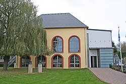
 Town hall | |
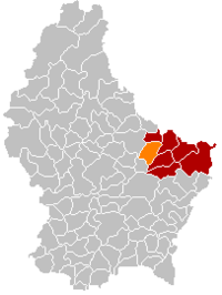
 Map of Luxembourg with Waldbillig highlighted in orange, and the canton in dark red | |
| Coordinates: 49°47′45″N 6°17′10″E / 49.7958°N 6.2861°E | |
| Country | |
| Canton | Echternach |
| Government | |
| • Mayor | Andrée Henx-Greischer |
| Area | |
• Total | 23.28 km2 (8.99 sq mi) |
| • Rank | 40th of 102 |
| Highest elevation | 387 m (1,270 ft) |
| • Rank | 63rd of 102 |
| Lowest elevation | 186 m (610 ft) |
| • Rank | 18th of 102 |
| Population (2023) | |
• Total | 1,960 |
| • Rank | 82nd of 102 |
| • Density | 84/km2 (220/sq mi) |
| • Rank | 78th of 102 |
| Time zone | UTC+1 (CET) |
| • Summer (DST) | UTC+2 (CEST) |
| LAU 2 | LU0001008 |
| Website | waldbillig.lu |
Waldbillig (Template:Lang-lb or (locally) Bëlleg [ˈbələɕ]) is a commune and small town in the canton of Echternach, Luxembourg.
As of 2020[update], the town of Waldbillig, which lies in the centre of the commune, has a population of 566. Other towns within the commune include Christnach with a population of 793 and Haller with a population of 413. Other localities include Mullerthal with 55 inhabitants and Freckeisen with a population of 50.[1]
History
Population
Graphs are unavailable due to technical issues. Updates on reimplementing the Graph extension, which will be known as the Chart extension, can be found on Phabricator and on MediaWiki.org. |
References
- ^ "Commune de Waldbillig". waldbillig.lu (in French). Retrieved 8 March 2023.
- ^ "Population par canton et commune". statistiques.public.lu. Retrieved 11 January 2022.
External links
 Media related to Waldbillig at Wikimedia Commons


