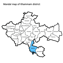
Madhira mandal
Appearance
Madhira mandal | |
|---|---|
 Madhira mandal highlighted in blue | |
| Coordinates: 16°55′00″N 80°22′00″E / 16.9167°N 80.3667°E | |
| Country | India |
| State | Telangana |
| District | Khammam |
| Headquarters | Madhira |
| Population (2011) | |
| • Total | 39,334 |
| Languages | |
| • Official | Telugu,English |
| Time zone | UTC+5:30 (IST) |
| Vehicle registration | TS04 |
| Website | telangana |
Madhira mandal is situated in the Khammam district of the Indian state of Telangana, falling within the Madhira Assembly Constituency[1] with Madhira as its headquarters. This area falls under Khammam revenue division.[2]
Villages
Villages in Madhira mandal, Telangana[3]
- Athkuru
- Amberpeta
- Chilukuru
- Dendukuru
- Didugupadu
- Illuru
- Jalimudi
- Khammampadu
- Madhira
- Madupalli
- Mallaram
- Maturu
- Munagala
- Nagarappadu
- Nakkalagarubu
- Nidanapuram
- Rayapatnam
- Rompimalla
- Siddinenigudem
- Siripuram (PM)
- Tondalagoparam
- Torlapadu
- Vangaveedu
- Yellandulapadu
- Yendapalli
References
- ^ "Madhira Assembly constituency (Telangana): Full details, live and past results". News18. Retrieved 2023-05-07.
- ^ "District Census Handbook – Khammam" (PDF). Census of India. The Registrar General & Census Commissioner. pp. 14, 46. Retrieved 1 June 2016.
- ^ "GOVERNMENT OF TELANGANA" (PDF).


