
Erez
Erez
ארז إيرز | |
|---|---|
 Erez in early 1949 | |
 Erez  Erez | |
| Coordinates: 31°33′36″N 34°33′58″E / 31.56000°N 34.56611°E | |
| Country | |
| District | Southern |
| Council | Shaʽar HaNegev |
| Affiliation | Kibbutz Movement |
| Founded | 1949 (original location) 1950 (current location) |
| Founded by | Noar HaOved |
| Population (2022)[1] | 616 |
| Website | www |
Erez (Hebrew: אֶרֶז, lit. 'cedar') is a kibbutz in southwestern Israel. Located just 1 kilometre (0.62 mi) north of the Gaza Strip, it is the namesake of the nearby Erez Crossing.
The kibbutz was founded in 1949 and moved to its current location in 1950. In 2019, it had a population of 558.[1]
Located in the northwestern Negev around 18 kilometres (11 mi) south of the coastal city of Ashkelon, it falls under the jurisdiction of the Shaʽar HaNegev Regional Council.
History
Erez is named after the first group that settled the kibbutz, who were members of the Noar HaOved from Petah Tikva. It was founded in 1949.
Economy
The kibbutz has three main industries: agriculture (arable and fruit farming as well as animal husbandry), manufacturing (Erez Thermoplastics Products manufactures plastic-covered materials), and research and development.[citation needed]
-
 The Dinning Room
 -
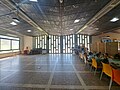 The Dinning Room
 -
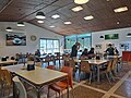 The Dinning Room
 -
 Protected space near the dinning room


See also
- Erez Crossing, a border crossing point between Israel and the Palestinian Gaza Strip
References
- ^ a b "Regional Statistics". Israel Central Bureau of Statistics. Retrieved 21 March 2024.
External links
- Official website (in Hebrew)