Krông Nô district
Appearance
You can help expand this article with text translated from the corresponding article in Vietnamese. (March 2009) Click [show] for important translation instructions.
|
Krông Nô district
Huyện Krông Nô | |
|---|---|
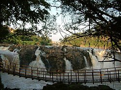
 Dray Sap Falls | |
 | |
| Country | |
| Region | Central Highlands |
| Province | Đắk Nông |
| Capital | Đắk Mâm |
| Area | |
• Total | 315 sq mi (817 km2) |
| Population (2018) | |
• Total | 70,003 |
| Time zone | UTC+7 (Indochina Time) |
Krông Nô is a rural district of Đắk Nông province in the Central Highlands region of Vietnam. As of 2003 the district had a population of 53,709.[1] The district covers an area of 817 km². The district capital lies at Đắk Mâm.[1]
References
- ^ a b "Districts of Vietnam". Statoids. Retrieved March 13, 2009.


