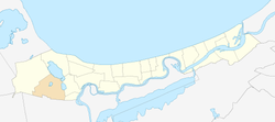
Kūdra
Appearance
Kūdra | |
|---|---|
 Location in Jūrmala | |
| Country | |
| City | Jūrmala |
| Area | |
• Total | 8.7 km2 (3.4 sq mi) |
| Elevation | 3 m (10 ft) |
| Population (2008)[1] | |
• Total | 123 |
| • Density | 14.1/km2 (37/sq mi) |
Kūdra is a residential area and neighbourhood of the city Jūrmala, Latvia.
The Kūdra railway station was established in 1951.
References
[edit]External links
[edit]![]() Media related to Kūdra at Wikimedia Commons
Media related to Kūdra at Wikimedia Commons
56°55′48″N 23°32′38″E / 56.930°N 23.544°E
