Shoshanat HaAmakim
Appearance
Shoshanat HaAmakim
שׁוֹשַׁנַּת הָעֲמָקִים | |
|---|---|
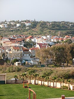
 Shoshanat HaAmakim, view from the south | |
| Coordinates: 32°21′14″N 34°51′24″E / 32.35389°N 34.85667°E | |
| Country | Israel |
| District | Central |
| Council | Hefer Valley |
| Founded | 1951 |
| Population (2022)[1] | 489 |
Shoshanat HaAmakim (Hebrew: שׁוֹשַׁנַּת הָעֲמָקִים, lit. 'Lily of the Valleys') is a community settlement in central Israel. Located to the north of Netanya, it falls under the jurisdiction of Hefer Valley Regional Council. In 2022 it had a population of 489.[1]
History
The village was established in 1951 and was built by the Rassco company. Its name is taken from the Song of Songs 2:1;
I am a rose of Sharon, a lily of the valleys.[2] (From modern Hebrew, this can also be translated as "lily of Sharon, a rose of the valleys".)
The neighbouring moshav Havatzelet HaSharon ("rose/lily of Sharon") is named after the first part of this verse.
References
- ^ a b "Regional Statistics". Israel Central Bureau of Statistics. Retrieved 21 March 2024.
- ^ Song of Songs Chapter 2 Mechon Mamre

