Rew, Pennsylvania
Appearance
Rew, Pennsylvania | |
|---|---|
 | |
| Country | United States |
| State | Pennsylvania |
| County | McKean |
| Area | |
• Total | 0.98 sq mi (2.54 km2) |
| • Land | 0.98 sq mi (2.54 km2) |
| • Water | 0.00 sq mi (0.00 km2) |
| Population | |
• Total | 159 |
| • Density | 162.08/sq mi (62.56/km2) |
| Time zone | UTC-5 (Eastern (EST)) |
| • Summer (DST) | UTC-4 (EDT) |
| ZIP codes | 16744 |
| FIPS code | 42-64296 |
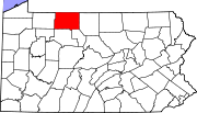
Rew is a census-designated place (CDP) in Foster Township, McKean County in the U.S. state of Pennsylvania. The community is almost halfway between Bradford and the borough and county seat of Smethport.
A notable attraction in Rew is the Bradford Speedway, location of a 1958 NASCAR race won by Junior Johnson.
Geography
[edit]Rew is located at the summit of a steep hill, where Pennsylvania Routes 46 and 646 intersect. It is located near the triple boundary of Foster, Otto and Keating Townships.
Demographics
[edit]| Census | Pop. | Note | %± |
|---|---|---|---|
| 2020 | 159 | — | |
| U.S. Decennial Census[3] | |||
As of the 2010 census, the population of Rew was 199, and was estimated 135 in the 2019 estimate. Every resident (100%) in the town was Caucasian. The median age and male ratio were also high, at 54.7 and 1:8:1, respectively.
References
[edit]- ^ "ArcGIS REST Services Directory". United States Census Bureau. Retrieved August 8, 2023.
- ^ "Census Population API". United States Census Bureau. Retrieved August 8, 2023.
- ^ "Census of Population and Housing". Census.gov. Retrieved June 4, 2016.

