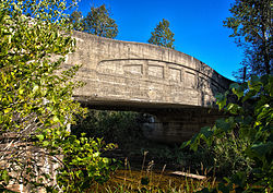
Ocqueoc River
| Ocqueoc River | |
|---|---|
 River Road over the Ocqueoc River. | |
 | |
| Location | |
| Country | United States |
| Physical characteristics | |
| Source | |
| • location | Bismarck Township, Presque Isle County, Michigan |
| Mouth | |
• location | Lake Huron at Ocqueoc Township, Presque Isle County, Michigan |
• elevation | 584 feet (178 m)[2] |
| Length | 34 miles (55 km)[1] |
| Basin size | 94,394 acres (382.00 km2)[3] |
| Basin features | |
| Tributaries | |
| • left | Silver Creek, Little Ocqueoc River, Indian Creek |
The Ocqueoc River (/ˈɑːkiːɑːk/ AH-key-ock) is a 34.2-mile-long (55.0 km)[1] blackwater river in the U.S. state of Michigan. The river is located in the northeastern Lower Peninsula, flowing into Lake Huron in Presque Isle County. The river drains a watershed of approximately 94,394 acres (382.00 km2).[3] Along the river are the Ocqueoc Falls, the largest and only named waterfall in Michigan's Lower Peninsula.[4][5]
Ocqueoc is a French adaptation of an Anishinabemowin (Ojibwe) term meaning "crooked waters".[6]
Description and course
The Ocqueoc River is the largest river entirely within Presque Isle County and drains several lakes, including Ocqueoc Lake, and receives a few tributaries, the largest being the Little Ocqueoc River and Silver Creek. The Ocqueoc River's source is in southern Bismarck Township at 45°13′15″N 83°55′45″W / 45.22083°N 83.92917°W approximately 10 miles (16 km) southeast of the village of Millersburg, which with a population 263 people at the 2000 Census is the largest community in the watershed.[7]
Ocqueoc Falls[8] are the largest waterfalls in the Lower Peninsula of Michigan with a drop of about 5 feet (1.5 m). The falls and the Ocqueoc Falls Bicentennial Pathway, which offers groomed winter trails and summer hiking trails, are a tourist attraction of Presque Isle County. The Ocqueoc River is one of the few rivers in the Lower Peninsula to flow north.[9]
The Ocqueoc River flows through a limestone karst region, and some of its tributaries, notably the Little Ocqueoc, are not continuous on the surface but flow through subterranean systems for part of their course. The upper reaches of the river's watershed is swampy with cedar, tamarack, balsam, poplar, aspen and black ash common. The warmer upper ranges have more warm-water fish including sunfish, pike and bass, while the lower cooler part of the river has salmon and trout.[10] Smelt dipping is a style of fishing used near the mouth of the Ocqueoc.
Drainage basin

The Ocqueoc River drainage basin includes all or portions of the following townships and municipalities in Presque Isle County:
A very small portion of the watershed is located in northern Montmorency County but contains no surface water.[3]
Named tributaries
Named waterbodies with direct surface flow into the Ocqueoc River system, from the mouth:
- Ocqueoc Lake[11]
- (right) Orchard Lake[12]
- Mud Lake[13]
- (left) Silver Creek[14]
- (left) Little Ocqueoc River[15]
- (right) Fox Creek[16]
- (left) Indian Creek[17]
- Upper Barnhart Lake[18]
- (right) McIntosh Lake[19]
- Lower Barnhart Lake[20]
- (left) Mud Lake[21]
- Lake Nettie[22]
References
- ^ a b U.S. Geological Survey. National Hydrography Dataset high-resolution flowline data. The National Map, accessed November 21, 2011
- ^ U.S. Geological Survey Geographic Names Information System: Ocqueoc River
- ^ a b c Ocqueoc River Watershed Management Plan, 2005, Ocqueoc River Watershed Commission, Accessed 22 August 2010
- ^ "Ocqueoc Falls Scenic Site". US-23 Heritage Route. Retrieved 2024-01-10.
- ^ "Michigan Recreation Search Site Details Page". www2.dnr.state.mi.us. Retrieved 2024-01-10.
- ^ Romig, Walter (1986) [1973]. Michigan Place Names. Detroit, Michigan: Wayne State University Press. ISBN 0-8143-1838-X.
- ^ "The Ocqueoc River Watershed- an Introduction", Bearinger Township, Presque Isle County, Michigan, December, 2008
- ^ "Ocqueoc Falls", Michigan Interactive
- ^ Area Attractions, Onaway Area Chamber of Commerce
- ^ Biological Survey of the Ocqueoc River, MI/DEQ/SWQ-96/017, Michigan Department of Environment Quality, April 1996
- ^ U.S. Geological Survey Geographic Names Information System: Ocqueoc Lake
- ^ U.S. Geological Survey Geographic Names Information System: Orchard Lake
- ^ U.S. Geological Survey Geographic Names Information System: Mud Lake
- ^ U.S. Geological Survey Geographic Names Information System: Silver Creek
- ^ U.S. Geological Survey Geographic Names Information System: Little Ocqueoc River
- ^ U.S. Geological Survey Geographic Names Information System: Fox Creek
- ^ U.S. Geological Survey Geographic Names Information System: Indian Creek
- ^ U.S. Geological Survey Geographic Names Information System: Upper Barnhart Lake
- ^ U.S. Geological Survey Geographic Names Information System: McIntosh Lake
- ^ U.S. Geological Survey Geographic Names Information System: Lower Barnhart Lake
- ^ U.S. Geological Survey Geographic Names Information System: Mud Lake
- ^ U.S. Geological Survey Geographic Names Information System: Lake Nettie
- ^ U.S. Geological Survey Geographic Names Information System: Bullhead Lake
- ^ U.S. Geological Survey Geographic Names Information System: Lake Ann
- ^ U.S. Geological Survey Geographic Names Information System: Horseshoe Lake
- ^ U.S. Geological Survey Geographic Names Information System: Lake Emma
- ^ U.S. Geological Survey Geographic Names Information System: Moores Lake
- ^ U.S. Geological Survey Geographic Names Information System: Marl Bed Lake
External links
- Minor WaterFalls, Great Lakes Waterfalls
