Jump to content

Chuya Belki

Coordinates: 49°57′09″N 87°33′38″E / 49.9525°N 87.5606°E / 49.9525; 87.5606
From Wikipedia, the free encyclopedia

This is an old revision of this page, as edited by Cydebot (talk | contribs) at 05:43, 18 April 2013 (Robot - Speedily moving category Altai to Category:Altai Mountains per CFDS.). The present address (URL) is a permanent link to this revision, which may differ significantly from the current revision.

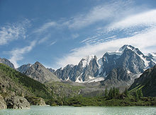
The Chuya Alps are part of the Altay mountain range, straddling the border of Russia and Kazakhstan close to the region where their borders and those of China and Mongolia meet. They have an average altitude of about 9000 ft with summits ranging from 11,500 to 12,000 ft. There are about ten glaciers found on the northern part of their slopes. They are named after the Chuya River.

49°57′09″N 87°33′38″E / 49.9525°N 87.5606°E / 49.9525; 87.5606