Tetsuo Harano Tunnels
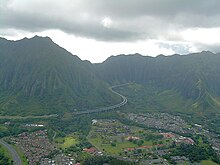
 Aerial view of the tunnel's eastern entrance. The smaller Hospital Rock Tunnels can be seen in the foreground, to the left. | |
| Overview | |
|---|---|
| Location | near Kaneohe, Hawaii |
| Coordinates | 21°24′12″N 157°50′07″W / 21.4033°N 157.8352°W |
| Route | |
| Technical | |
| Length | 4,980 feet (1,520 m) Kaneohe bound 5,165 feet (1,574 m) Halawa bound |
| No. of lanes | 4 |
The Tetsuo Harano Tunnels are a pair of highway tunnels passing through the Ko‘olau Range on the island of O‘ahu. The tunnels are located on Interstate H-3, which connects Kaneohe with Interstate H-1 at Hālawa near Pearl Harbor, and are 4,980 feet (1,520 m) long Kaneohe-bound and 5,165 feet (1,574 m) long Halawa-bound.
The tunnels are named for Tetsuo Harano, a former state highways administrator who served the state for 52 years. The tunnels were briefly renamed for the former Governor of Hawaii John A. Burns but restored to the original name by Governor Linda Lingle after she took office.[1]
Also nearby are the smaller Hospital Rock Tunnels.
References
- ^ "Governor Lingle Restores Name of H-3 Tunnel and Returns Original Honor to Tetsuo Harano". Office of the Governor of Hawaii. December 18, 2002. Retrieved January 1, 2015.
