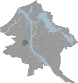
Iļģuciems
This article needs additional citations for verification. (February 2014) |
You can help expand this article with text translated from the corresponding article in Latvian. (March 2011) Click [show] for important translation instructions.
|
Iļģuciems | |
|---|---|
Neighborhood of Riga | |
 Buļļu street in Iļģuciems | |
 Location in Riga | |
| Coordinates: 56°58′N 24°04′E / 56.967°N 24.067°E | |
| Country | |
| City | Riga |
| District | Kurzemes rajons |
| Area | |
| • Total | 2.442 km2 (0.943 sq mi) |
| Population (2008) | |
| • Total | 26,131 |
| Time zone | UTC+2 (EET) |
| • Summer (DST) | UTC+3 (EEST) |
Iļģuciems is one of the older neighbourhoods situated in the Pārdaugava side of Riga.[1]
References
- ^ Normunds Strautmanis and Maija Rozīte, "ASSESSMENT OF EUROPEAN COMMISSION’S REGIONAL POLICY IMPACT ON REAL ESTATE INVESTMENT IN A POST-SOVIET CITY: CASE STUDY OF SELECTED NEIGHBOURHOODS IN RIGA, LATVIA, European Integration Studies no. 6 (2012)
