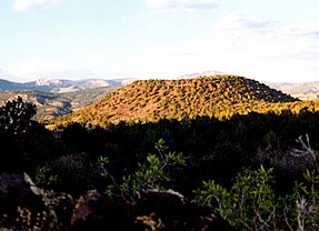
Bald Knoll
| Bald Knoll | |
|---|---|
 Bald Knoll is the youngest of a group of cinder cones on the SW part of the Paunsaugunt Plateau in southern Utah. | |
| Highest point | |
| Elevation | 7,003 ft (2,135 m)[1] |
| Coordinates | 37°19′36″N 112°24′37″W / 37.32667°N 112.41028°W |
| Geology | |
| Mountain type | Cinder cone |
| Last eruption | Unknown |
Bald Knoll, also called Black Knoll, Buck Knoll or Corral Knoll,[2] is a cinder cone in Utah, in the Southwestern United States.
It is the youngest volcano at the southwest portion of the Paunsaugunt Plateau and it consists of basaltic lava with a well-preserved volcanic crater at its summit.[1]
References
- ^ a b "Bald Knoll". Global Volcanism Program. Smithsonian Institution.
- ^ "Bald Knoll". Volcano Global Risk Identification and Analysis Project (VOGRIPA). February 5, 2012. Retrieved February 15, 2014.
