Jump to content

Feuerspitze

Coordinates: 47°12′0″N 10°22′0″E / 47.20000°N 10.36667°E / 47.20000; 10.36667
From Wikipedia, the free encyclopedia

This is the current revision of this page, as edited by JJMC89 bot (talk | contribs) at 09:02, 17 April 2017 (Migrate {{Infobox mountain}} coordinates parameters to {{Coord}}, see Wikipedia:Coordinates in infoboxes). The present address (URL) is a permanent link to this version.

(diff) ← Previous revision | Latest revision (diff) | Newer revision → (diff)
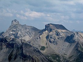
Feuerspitze
Wetterspitze (left) and Feuerspitze (right), seen from the southwest
Highest point
Elevation2,852 m (9,357 ft)
Coordinates47°12′0″N 10°22′0″E / 47.20000°N 10.36667°E / 47.20000; 10.36667
Geography
Feuerspitze is located in Austria
Feuerspitze
Feuerspitze
Austria
LocationTyrol, Austria
Parent rangeLechtal Alps

Feuerspitze ("Fire-Peak") is a mountain in the Lechtal Alps of Tyrol. The elevation at its peak is 2,852 metres (9,357 ft). Feuerspitze is located 7 kilometres (4.3 mi) southeast of Holzgau.

⁠ ⁠ ⁠