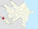
Xanlıqlar, Nakhchivan
Xanlıqlar | |
|---|---|
Municipality | |
| Coordinates: 39°30′10″N 45°01′43″E / 39.50278°N 45.02861°E | |
| Country | |
| Autonomous republic | Nakhchivan |
| Rayon | Sharur |
| Population (2005)[citation needed] | |
| • Total | 2,091 |
| Time zone | UTC+4 (AZT) |
Xanlıqlar (also, Khanlykhlar, Khanlyklar, and Khannykhlar) is a village and municipality in the Sharur Rayon of Nakhchivan, Azerbaijan. It is located 8 km in the south-east from the district center, on the Sharur plain. Its population is busy with vine-growing and animal husbandry. There are grape processing factory, secondary school, club, library and a medical center in the village. It has a population of 2,091. There exist a sanctuary named "Imamzade" in the village.[1]
Etymology
The settlement was so named because it has been built in the property territory named Xanlıq (Khanate) which belonged to the Nakhchivan Khans.[2]
References
- ^ ANAS, Azerbaijan National Academy of Sciences (2005). Nakhchivan Encyclopedia. Vol. volume I. Baku: ANAS. p. 249. ISBN 5-8066-1468-9.
{{cite book}}:|volume=has extra text (help) - ^ Encyclopedic dictionary of Azerbaijan toponyms. In two volumes. Volume I. p. 304. Baku: "East-West". 2007. ISBN 978-9952-34-155-3.


