Anderen
Appearance
Anderen | |
|---|---|
Town | |
 | |
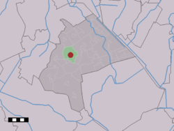
 The village (dark red) and the statistical district (light green) of Anderen in the municipality of Aa en Hunze. | |
| Coordinates: 53°0′1″N 6°41′8″E / 53.00028°N 6.68556°E | |
| Country | Netherlands |
| Province | Drenthe |
| Municipality | Aa en Hunze |
| Population (1 January 2007) | |
| • Total | 255 |
| Time zone | UTC+1 (CET) |
| • Summer (DST) | UTCCBS (cbs) |
Anderen is a town in the Dutch province of Drenthe. It is a part of the municipality of Aa en Hunze, and lies about 8 km east of Assen.
The statistical area "Anderen", which can also include the surrounding countryside, has a population of around 260.[1]
Transportation
There is no railway station here. The nearest station is Assen station. There are no bus services either, but bus services 10 and 28 stop 1 km south of Anderen on the road cbs.
For further information see Aa en Hunze#Transportation.
References
- ^ Statistics Netherlands (CBS), Statline: Kerncijfers wijken en buurten 2003-2005. As of 1 January 2005.
