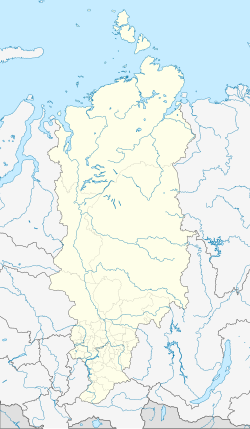
Zelenogorsk, Krasnoyarsk Krai
Zelenogorsk
Зеленогорск | |
|---|---|
 View of Zelenogorsk | |
| Coordinates: 56°06′00″N 94°35′00″E / 56.10000°N 94.58333°E | |
| Country | Russia |
| Federal subject | Krasnoyarsk Krai[1] |
| Founded | 1956 |
| Town status since | 1956 |
| Government | |
| • Head | Alexander Morgunov |
| Elevation | 170 m (560 ft) |
| Population | |
| • Total | 66,056 |
| • Rank | 237th in 2010 |
| • Subordinated to | closed administrative-territorial formation of Zelenogorsk[1] |
| • Capital of | closed administrative-territorial formation of Zelenogorsk[1] |
| • Urban okrug | Zelenogorsk Urban Okrug[3] |
| • Capital of | Zelenogorsk Urban Okrug[3] |
| Time zone | UTC+7 (MSK+4 |
| Postal code(s)[5] | 663690 |
| Dialing code(s) | +7 39169 |
| OKTMO ID | 04737000001 |
| Website | www |
Zelenogorsk (Russian: Зеленогорск, IPA: [zʲɪlʲɪnɐˈgorsk]) is a closed town in Krasnoyarsk Krai, Russia, located on the left bank of the Kan River 180 kilometers (110 mi) above its confluence with the Yenisei River. It was formerly known as Krasnoyarsk-45 (Красноя́рск-45) and was involved in enriching uranium for the Soviet nuclear program. Population: 66,056 (2010 Census);[2] 69,355 (2002 Census).[6]
History
It was granted town status in 1956.[citation needed]
As a closed town, it went under the codename Krasnoyarsk-45 until Russian President Boris Yeltsin decreed in 1992 that such cities could use their historical names. The town appeared on no official maps until then. As is the tradition with Soviet towns containing secret facilities, Krasnoyarsk-45 is actually a number of post office and implied that the place was located directly in the city of Krasnoyarsk, but really at the distance of 160 kilometers (99 mi) from it.
Administrative and municipal status
Within the framework of administrative divisions, it is incorporated as the closed administrative-territorial formation of Zelenogorsk—an administrative unit with the status equal to that of the districts.[1] As a municipal division, the closed administrative-territorial formation of Zelenogorsk is incorporated as Zelenogorsk Urban Okrug.[3]
International relations
It is a sister city with Newburyport, Massachusetts, United States.[citation needed]
References
Notes
- ^ a b c d e Law #10-4765
- ^ a b Russian Federal State Statistics Service (2011). Всероссийская перепись населения 2010 года. Том 1 [2010 All-Russian Population Census, vol. 1]. Всероссийская перепись населения 2010 года [2010 All-Russia Population Census] (in Russian). Federal State Statistics Service.
- ^ a b c Law #14-3412
- ^ "Об исчислении времени". Официальный интернет-портал правовой информации (in Russian). June 3, 2011. Retrieved January 19, 2019.
- ^ Почта России. Информационно-вычислительный центр ОАСУ РПО. (Russian Post). Поиск объектов почтовой связи (Postal Objects Search) (in Russian)
- ^ Federal State Statistics Service (May 21, 2004). Численность населения России, субъектов Российской Федерации в составе федеральных округов, районов, городских поселений, сельских населённых пунктов – районных центров и сельских населённых пунктов с населением 3 тысячи и более человек [Population of Russia, Its Federal Districts, Federal Subjects, Districts, Urban Localities, Rural Localities—Administrative Centers, and Rural Localities with Population of Over 3,000] (XLS). Всероссийская перепись населения 2002 года [All-Russia Population Census of 2002] (in Russian).
Sources
- Законодательное собрание Красноярского края. Закон №10-4765 от 10 июня 2010 г. «О перечне административно-территориальных единиц и территориальных единиц Красноярского края», в ред. Закона №7-3007 от 16 декабря 2014 г. «Об изменении административно-территориального устройства Большеулуйского района и о внесении изменений в Закон края "О перечне административно-территориальных единиц и территориальных единиц Красноярского края"». Вступил в силу 1 июля 2010 г. Опубликован: "Ведомости высших органов государственной власти Красноярского края", №33(404), 5 июля 2010 г. (Legislative Assembly of Krasnoyarsk Krai. Law #10-4765 of June 10, 2010 On the Registry of the Administrative-Territorial Units and the Territorial Units of Krasnoyarsk Krai, as amended by the Law #7-3007 of December 16, 2014 On Changing the Administrative-Territorial Structure of Bolsheuluysky District and on Amending the Krai Law "On the Registry of the Administrative-Territorial Units and the Territorial Units of Krasnoyarsk Krai". Effective as of July 1, 2010.).
- Законодательное собрание Красноярского края. Закон №14-3412 от 26 мая 2005 г. «О статусе закрытых административно-территориальных образований Красноярского края», в ред. Закона №8-2948 от 19 февраля 2009 г. «О внесении изменения в статью 1 Закона края «О статусе закрытых административно-территориальных образований Красноярского края»». Вступил в силу через десять дней после официального опубликования. Опубликован: "Ведомости высших органов государственной власти Красноярского края", №26, 23 июня 2005 г. (Legislative Assembly of Krasnoyarsk Krai. Law #14-3412 of May 26, 2005 On the Status of the Closed Administrative-Territorial Formations of Krasnoyarsk Krai, as amended by the Law #8-2948 of February 19, 2009 On Amending Article 1 of the Krai Law "On the Status of the Closed Administrative-Territorial Formations of Krasnoyarsk Krai". Effective as of ten days after the official publication.).


